- Home Page /
- Office Products /
- Office & School Supplies /
- Education & Crafts /
- Geography Materials /
- Maps /
- Antiguos Maps Holy Land Showing Historical Bo...
0 ratings


Item #:
32750075
Antiguos Maps Holy Land Showing Historical Boundaries, Roads, Railways and Places Named in the New Testament circa 1923 | Vintage Wall Decor | Art
Item #:
32750075
USD 27
Price Details
Excluding Shipping & Custom charges ( Shipping and custom charges will be calculated on checkout )
*All items will import from US
0 ratings
Write a review
In stock
QTY:
Order now and get it around Friday, July 03
Secured transaction
Ubuy works hard to protect your security and privacy. Our advanced payment security system ensures confidentiality by encrypting your information during transmission using AES (Advanced Encryption Standards) and SSL (Secure Socket Layer) protocols. Your payment details are 100% secure as we do not share your payment details with third party sellers.
Our Top Logistics Partners
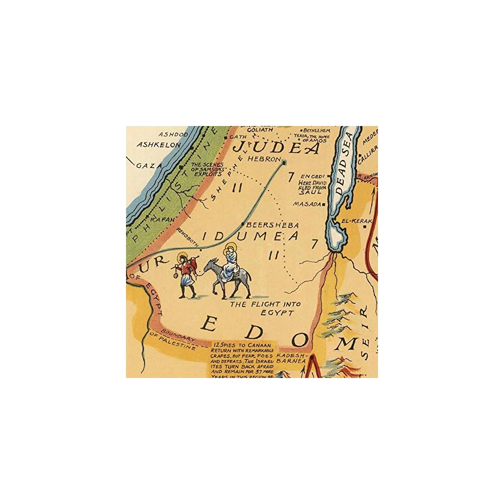
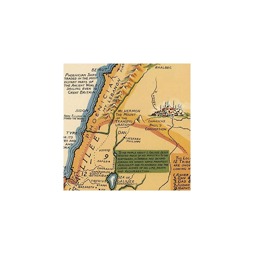
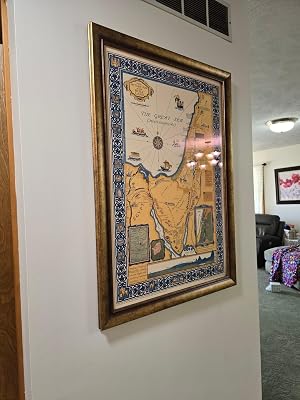
Map of Holy Land Showing Historical Boundaries, Roads, Railways and Places Named in the New Testament circa 1923.
Fast
Shipping
Free
Return*
Secure Packaging
100% Original Products
PCI DSS Compliance

ISO 27001 Certified
Note: Step 1 Voltage Transformer required for using electronics products of US store (110-120). Recommended power converters Buy Now.


What Stands Out
Historic Artwork
This vintage map art print from 1923 showcases historical boundaries and locations in the Holy Land, making it a timeless addition to any decor while sparking curiosity and conversation.
Educational Value
Perfect for history buffs and educators, this map provides insight into New Testament geography, enhancing understanding of significant events and locations, thereby enriching the learning experience.
Stunning Decor
With dimensions of 24 x 36 inches, this striking wall decor piece elevates any space, combining aesthetics with a unique historical narrative that captivates both guests and residents alike.
Product Details
- Vintage wall decor featuring a map of the Holy Land circa 1923
- Printed on high-quality, water-resistant, tear-proof satin polypropylene paper
- Digitally refined and giclee printed in the United States with OEM ink sets
- Comes in a size of 24 x 36 inches (610 x 915 mm), designed to fit standard frames
- Items are as pictured and satisfaction is guaranteed
- Shipped promptly in a heavy gauge mailing tube for protection
| Brand Name | Antiguos Maps |
| Map Type | Historical |
| Manufacturer | Antiguos Maps |
| Part Number | Carlson Brands |
| Paper Size | 24 x 36 inches (61 cm) |
| Item Weight | 8 Ounces (226.8 grams) |
| Item Dimensions L x W | 36"L x 24"W (91.4 cm) |
| Color | Multi |
| Paper Finish | Satin |
| Brand | Antiguos Maps |
| Sheet Size | 24 x 36 inches (61 cm) |
Who Should Buy?

-
History Enthusiasts
Perfect for those interested in biblical history or the geographical context of the New Testament.
-
Home Decorators
Aesthetic vintage wall decor suitable for living rooms, studies, or classrooms, adding a touch of history.
-
Educational Use
Useful for educators teaching biblical studies or geography, providing visual aids for students.

-
Casual Buyers
Not ideal for those looking for generic wall art without specific historical or educational context.
-
Modern Aesthetic Lovers
May not appeal to those who prefer contemporary or minimalistic artwork over vintage styles.
-
Budget-Conscious Shoppers
Could be considered expensive for potential buyers seeking affordable wall decor alternatives.
Product Description
About This Item
Bring a piece of history and culture into your home with our Antiguos Maps Holy Land vintage art print poster. Measuring at 24 x 36 inches (610 x 915 mm), this stunning antique map showcases the historical boundaries, roads, railways, and places named in the New Testament, dating back to circa 1923. Step back in time as you marvel at the intricate details and craftsmanship of this vintage wall decor. The faded hues and delicate lines of the map evoke a sense of nostalgia, adding a touch of charm to any room.
Whether you're a history enthusiast, a religious scholar, or simply someone who appreciates the beauty of vintage art, this Holy Land art print poster is a must-have addition to your collection. This vintage map of the Holy Land serves both as a decorative statement and a conversation starter. Hang it in your living room, study, or hallway, and let it transport you to a bygone era. Its timeless appeal makes it a perfect gift for history buffs, travelers, or anyone who wants to adorn their walls with a unique piece of artwork. Crafted with care, this art print poster is made to last.
Printed on high-quality paper, it ensures longevity and durability, allowing you to enjoy its beauty for years to come. The large size of 24 x 36 inches (610 x 915 mm) makes it a focal point wherever it is displayed. Don't miss out on the chance to own a piece of history. Enhance your home with our Antiguos Maps Holy Land vintage art print poster and let its beauty and historical significance capture your imagination.
Explore the rich heritage of the Holy Land through the lens of this antique map and make a statement with your wall decor.
Have any Query? Chat with us
Customer Questions & Answers
-
Question:
What features are depicted on the Antiguos Maps of the Holy Land?
Answer: The Antiguos Maps of the Holy Land prominently showcase historical boundaries, roads, railways, and significant locations mentioned in the New Testament. These elements are carefully illustrated, allowing you to visualize the geographical context of biblical events. By studying these maps, you can gain insights into how ancient roads and settlements influenced the movement and interactions of biblical figures. They serve as a historical reference as well as a decorative piece, making them ideal for homes, offices, or educational settings. -
Question:
What is the historical significance of these maps?
Answer: These maps are not just artistic representations; they hold immense historical significance as they reflect the geographical understanding of the Holy Land circa 1923. They can serve as educational tools to explore the development of the region over centuries. Additionally, they help contextualize significant biblical narratives and events, making them a valuable resource for history enthusiasts, educators, or those looking to deepen their faith. Displaying such maps can spark conversations and provide a deeper understanding of religious history. -
Question:
Are these maps suitable for home decor?
Answer: Absolutely! The Antiguos Maps of the Holy Land are designed not only to inform but also to enhance your living space. Their vintage aesthetic adds a classic touch to various decor styles, such as traditional, rustic, or eclectic. You can use these maps to create a focal point in your living room, study, or classroom, merging art with historical learning. They are perfect for those looking to incorporate meaningful decor or inspire curiosity among family and guests. -
Question:
How can I incorporate these maps into my interior design?
Answer: Incorporating the Antiguos Maps of the Holy Land into your interior design can be both fun and meaningful. You can frame them individually or as a series to create an art gallery wall, or use them as statement pieces above a mantle or in a reading nook. Pair them with complementary decor items, such as antique bookends or globes, to create a cohesive vintage theme. These maps also work well in study rooms or libraries, combining aesthetics with scholarly inspiration. -
Question:
What materials are the maps printed on?
Answer: The Antiguos Maps of the Holy Land are typically printed on high-quality, durable paper that enhances the rich colors and intricate details. The craftsmanship involves archival inks that ensure longevity, preserving the vintage appeal of the map for years to come. This makes them not just art but a lasting piece of history that will maintain its vibrancy over time, perfect for display without fear of discoloration or damage. -
Question:
Can these maps be used in educational settings?
Answer: Yes, these maps can be an excellent educational resource in classrooms, particularly for history and religious studies. They provide students with tangible context regarding biblical narratives and historical geography. Teachers can use these maps to illustrate lessons about ancient civilizations, trade routes, and cultural exchanges. This visual learning tool encourages engagement and can spark discussions about historical significance, making learning more interactive. -
Question:
What size options are available for these maps?
Answer: The Antiguos Maps of the Holy Land typically come in various sizes to cater to diverse display needs. From large wall hangings that serve as statement pieces to smaller prints suited for desk displays or bookshelves, there is an option for every preference. Choosing the right size depends on your intended use, whether it’s for a prominent display in a living room or subtle placement in an office setting. Ensure you pick a size that complements your space. -
Question:
Are there any care tips for maintaining the maps?
Answer: To maintain the beauty of the Antiguos Maps of the Holy Land, avoid placing them in direct sunlight, as this can lead to fading over time. Dust them gently with a soft, dry cloth to keep them looking fresh and clean. If you frame them, using UV-protective glass can further preserve their colors and details. By taking these simple care steps, you can ensure your maps remain a stunning highlight in your home or office. -
Question:
Where can I buy Antiguos Maps Holy Land Showing Historical Boundaries, Roads, Railways and Places Named in the New Testament?
Answer: You can purchase the Antiguos Maps of the Holy Land through Ubuy. This platform offers a wide selection of vintage wall decor, including these historically rich maps. Ubuy provides a convenient shopping experience, often featuring different styles and sizes to match your decor needs. Simply visit Ubuy and search for the product to explore your options for acquiring this unique piece of art and history.
AntiguosMaps Maps Editorial Review


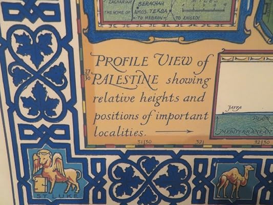
The Map of Holy Land Showing Historical Boundaries, Roads, Railways and Places Named in the New Testament circa 1923 is a high-quality and beautiful poster. The colors are vibrant and the silk paper feels luxurious. It is perfect for education and studying ancient Israel. However, there is a minor inaccuracy with the name 'Palestine' being mentioned three times on the insets, which did not exist during the depicted time. Overall, it is a beautiful piece of art that is highly recommended.
Customer Reviews & Ratings
63 customers ratings
-
5 Star
84%
-
4 Star
13%
-
3 Star
0%
-
2 Star
3%
-
1 Star
0%
Review this product
Share your thoughts with other customers
Pros
- High quality and beautiful
- Vibrant colors
- Luxurious silk paper
- Perfect for education and studying ancient Israel
Cons
- Minor inaccuracy with the name 'Palestine' mentioned
Product Price History
Important information
- Limitations : For products shipped internationally, please note that any manufacturer warranty may not be valid; manufacturer service options may not be available; product manuals, instructions, and safety warnings may not be in destination country languages; the products (and accompanying materials) may not be designed in accordance with destination country standards, specifications, and labeling requirements; and the products may not conform to destination country voltage and other electrical standards (requiring use of an adapter or converter if appropriate). The recipient is responsible for assuring that the product can be lawfully imported to the destination country. When ordering from Ubuy or its affiliates, the recipient is the importer of record and must comply with all laws and regulations of the destination country.
- Not all the products listed on Ubuy are for sale, as Ubuy is a global search engine. Products are subject to export/trade regulations.
USD 27
Order now and get it around Friday, July 03
This item is not restrict in my country.(Please click on above link if this item is not restrict in your country, So our team will review and allow.)
QTY:
Secured transaction
Ubuy works hard to protect your security and privacy. Our advanced payment security system ensures confidentiality by encrypting your information during transmission using AES (Advanced Encryption Standards) and SSL (Secure Socket Layer) protocols. Your payment details are 100% secure as we do not share your payment details with third party sellers.
Our Top Logistics Partners
Fastest cross-border delivery
Features & Benefits
- Measures 24 inches x 36 inches (610 mm x 915 mm).
- Reproduced in the U.S.A with the highest quality.
- Giclee printed on high-end, thick, water-resistant & tear-proof polypropylene paper using high-grade OEM inks.
- Shows Historical Boundaries, Roads, Railways and Places Named in the New Testament circa 1923.
- Ships rolled in a heavy-gauge mailing tube.
- Quality is something we don't compromise on.