- Home Page /
- Electronics /
- GPS, Finders & Accessories /
- Sports & Handheld GPS /
- Handheld GPS Units /
- R26 V1 NOAA GNSS IMU RTK GPS Land Surveying E...
0 ratings

Item #:
64110780
R26 V1 NOAA GNSS IMU RTK GPS Land Surveying Equipment Rover Base Collector and Survey Software Included, NOAA certificated, 1cm AccuracyExclude
Item #:
64110780
USD 2958
Price Details
Excluding Shipping & Custom charges ( Shipping and custom charges will be calculated on checkout )
*All items will import from US
0 ratings
Write a review
Out of stock
Secured transaction
Ubuy works hard to protect your security and privacy. Our advanced payment security system ensures confidentiality by encrypting your information during transmission using AES (Advanced Encryption Standards) and SSL (Secure Socket Layer) protocols. Your payment details are 100% secure as we do not share your payment details with third party sellers.
Our Top Logistics Partners
Surveying equipment R26 enables surveyors and experts to precisely pinpoint the coordinates and elevations of places on the surface of the Earth, producing maps, calculating distances, and drawing borders.
Fast
Shipping
Free
Return*
Secure Packaging
100% Original Products
PCI DSS Compliance

ISO 27001 Certified
Note: Step 1 Voltage Transformer required for using electronics products of US store (110-120). Recommended power converters Buy Now.


What Stands Out
NOAA Certification
The R26 V1 is NOAA certified, ensuring compliance with high standards in land surveying. This certification adds credibility, making it a trusted choice for professionals who require reliable and accurate surveying equipment.
1cm Accuracy
Achieving an impressive 1cm accuracy, this GPS equipment drastically reduces errors in land measurements, providing users with precise data essential for expert-level surveying and engineering tasks.
Comprehensive Software
Included survey software enhances the usability of the R26 V1, streamlining data collection and analysis. This integration improves efficiency, making it easier for surveyors to manage projects effectively.
Product Details
- Supports R26 Radio Protocol with a 2 kilometer range between rover and base
- Utilized by surveyors to measure distances, angles, elevations, and coordinates for mapping land characteristics
- Fully supports BDS, GPS, GLONASS, Galileo systems for global adaptability
- Versatile use for various types of surveying and engineering work such as land surveying, geographic information, and mine surveying
- Features built-in Bluetooth, radio, storage, positioning, and inertial navigation modules for diverse measurement needs
- Software is updateable and permanently valid, with surveying software pre-installed in the handheld device
| Item Weight | 3.5 lbs (1.59 kg) |
Who Should Buy?

-
Land Surveyors
Professional surveyors needing high accuracy for mapping and land measurement will greatly benefit from this equipment.
-
Construction Firms
Companies in construction require precise surveying tools to ensure accurate site layouts and planning for projects.
-
Environmental Researchers
Researchers conducting environmental studies can use this tool for precise location tracking and data collection in the field.

-
Casual Users
Hobbyists or casual users may find this equipment overly complex and not necessary for their basic surveying needs.
-
Budget-Conscious Buyers
Those looking for low-cost surveying options may not afford or justify the investment in this high-end equipment.
-
Short-Term Projects
Users needing equipment for brief projects may find it more economical to rent rather than purchase this device.
Product Description
R26 V1 NOAA GNSS IMU RTK GPS Land Surveying Equipment Rover Base Collector and Survey Software Included, NOAA certificated, 1cm AccuracyExclude Tripod&Pole
Have any Query? Chat with us
Customer Questions & Answers
-
Question:
What is the R26 V1 NOAA GNSS IMU RTK GPS Land Surveying Equipment?
Answer: The R26 V1 is a highly advanced GNSS IMU RTK GPS land surveying equipment designed for precision surveying tasks. Equipped with NOAA certification, this device provides 1cm accuracy, making it suitable for a variety of applications in land development and construction projects. Its features include a rover base collector and integrated survey software, ensuring that all necessary tools are available for efficient and accurate surveying operations. -
Question:
How accurate is the R26 V1 GPS equipment?
Answer: The R26 V1 provides an impressive accuracy level of 1cm, which is crucial for high-precision surveying tasks. This level of accuracy is achieved through Real-Time Kinematic (RTK) technology that corrects GPS signals in real-time using a base station. Users such as surveyors, engineers, and construction professionals will find this level of precision invaluable for projects where even minor errors can have significant implications. -
Question:
What are the key benefits of using NOAA certified equipment?
Answer: Using NOAA certified equipment like the R26 V1 ensures compliance with rigorous industry standards. This certification guarantees that the device has been tested for its reliability and accuracy, providing users with peace of mind. For professionals involved in environmental studies, agriculture, and resource management, using NOAA certified equipment like the R26 V1 can enhance project credibility and regulatory compliance. -
Question:
Is the survey software included easy to use?
Answer: Yes, the included survey software is designed for ease of use, featuring an intuitive interface that allows users to efficiently manage data collection and analysis. The software simplifies complex surveying tasks, making it accessible for both seasoned professionals and newcomers. The ease of navigation and data management enhances workflow efficiency during surveying tasks. -
Question:
Can the R26 V1 be used for mobile and remote surveying?
Answer: Absolutely! The R26 V1 is designed for flexibility in various surveying environments, including mobile and remote locations. Its lightweight and portable design, combined with robust GNSS capabilities means it can be deployed in challenging terrains, making it ideal for projects like construction site surveys or agricultural land assessments where mobility is key. -
Question:
What applications is the R26 V1 suitable for?
Answer: The R26 V1 excels in various surveying applications, including land surveying, civil engineering, mapping, and environmental studies. Its high accuracy and reliable performance make it particularly beneficial for professionals needing detailed surveys for construction projects, agricultural land planning, and environmental monitoring, ensuring that all data collected meets high standards. -
Question:
How does the RTK technology work in the R26 V1?
Answer: RTK technology works by using a stationary base station to transmit correction data to the R26 V1 rover. This allows for real-time corrections of GPS signals, resulting in centimeter-level accuracy. For surveyors, this technology is a game-changer, enabling them to gather precise data rapidly and efficiently, which is particularly useful in large-scale land development projects. -
Question:
What makes the R26 V1 a reliable choice for professionals?
Answer: The R26 V1's combination of NOAA certification, high accuracy, and user-friendly software establishes it as a trustworthy choice for surveying professionals. Its proven reliability in various environmental conditions and rigorous testing ensures that professionals can depend on it for critical tasks, enabling them to deliver high-quality work to their clients. -
Question:
How can I ensure proper maintenance of the R26 V1?
Answer: To maintain the R26 V1, regularly clean its components, especially the antenna and connections, and store it in a protective case when not in use. Additionally, keep the software updated to benefit from improved functionalities. Proper maintenance maximizes device lifespan and ensures accuracy during use, making it essential for repeated workflows. -
Question:
Where can I buy the R26 V1 NOAA GNSS IMU RTK GPS equipment?
Answer: You can purchase the R26 V1 NOAA GNSS IMU RTK GPS Land Surveying Equipment from Ubuy, a reliable e-commerce platform that offers a variety of high-quality surveying tools. Ubuy provides fast shipping and excellent customer service, ensuring you receive your equipment promptly and can access support if needed. By choosing Ubuy, you're also ensured a hassle-free shopping experience with user-friendly navigation and secure payment options.
SMAJAYU Handheld GPS Units Editorial Review
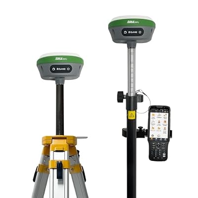
The SMAJAYU RTK Surveying System is a comprehensive system designed for Construction and geodetic surveying or layout planning with centimeter-level measurement accuracy. It includes an RTK rover, base and handheld surveying system to capture and record real-time positions accurately. The system can receive Ntrip correction for precise measurements. It also supports static surveying and exports text format files which can be converted to RINEX format. Additionally, the system provides elevation data and can be used internationally. The R26 rover and base both include internal battery, 10000mah. Overall, the SMAJAYU RTK Surveying System appears to deliver accurate and reliable results. It offers a range of features and capabilities for surveyors working in the Construction and geodetic industries. The inclusion of Ntrip correction and the ability to log static data provide added flexibility and convenience for users.
Customer Reviews & Ratings
1 customers ratings
-
5 Star
0%
-
4 Star
100%
-
3 Star
0%
-
2 Star
0%
-
1 Star
0%
Review this product
Share your thoughts with other customers
Pros
- Accurate and reliable measurements
- Supports Ntrip correction
- Provides elevation data
- Supports static surveying
- Internal battery included in rover and base
Cons
- External radio may be necessary to extend signal range (not included)
Product Price History
Important information
- Limitations : For products shipped internationally, please note that any manufacturer warranty may not be valid; manufacturer service options may not be available; product manuals, instructions, and safety warnings may not be in destination country languages; the products (and accompanying materials) may not be designed in accordance with destination country standards, specifications, and labeling requirements; and the products may not conform to destination country voltage and other electrical standards (requiring use of an adapter or converter if appropriate). The recipient is responsible for assuring that the product can be lawfully imported to the destination country. When ordering from Ubuy or its affiliates, the recipient is the importer of record and must comply with all laws and regulations of the destination country.
- Not all the products listed on Ubuy are for sale, as Ubuy is a global search engine. Products are subject to export/trade regulations.
USD 2958
Currently unavailable.
We don't know when or if this item will be back in stock.
This item is not restrict in my country.(Please click on above link if this item is not restrict in your country, So our team will review and allow.)
Secured transaction
Ubuy works hard to protect your security and privacy. Our advanced payment security system ensures confidentiality by encrypting your information during transmission using AES (Advanced Encryption Standards) and SSL (Secure Socket Layer) protocols. Your payment details are 100% secure as we do not share your payment details with third party sellers.
Our Top Logistics Partners
Fastest cross-border delivery
Features & Benefits
- SMAJAYU RTK Surveying System helps measure and map land characteristics with precision.
- Fully supports various systems like BDS, GPS, GLONASS, Galileo.
- Can be used for different surveying types like Point Survey, Detail Survey, Point Stakeout and Line Stakeout.
- Built-in Bluetooth, radio, storage, positioning, and other modules meet a variety of measurement needs.
- Software can be updated and is permanently valid.
- Ranges up to 2 kilometers between rover and base is possible with the R26 Radio Protocol.